
Welcome to the Known Land of Pasaron!
As with the text of The Proving, the map below is a work in progress. I hope to somehow create a very fancy, very “clean” version of the map in the future (God willing with the help of some excellent publishing company!), but this should suffice to orient early readers to the locales in The Proving. Below the map is a brief tour to help comprehend my messy penmanship. Click to enlarge.
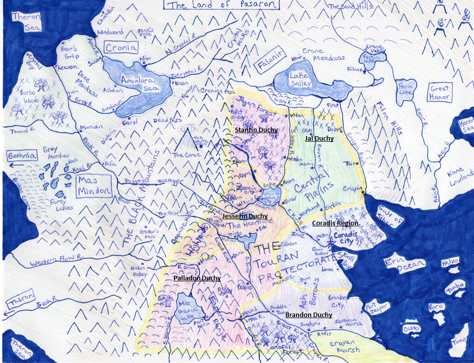
The Touran Protectorates, outlined in yellow, are comprised of five duchies and the Coradis region. Think of each duchy as a state, and think of the one region as Washington DC… not really a state, but a thing of its own.
Beginning at the lower right we have the Erin Ocean and the five Blue Islands. The Blue Islands are part of the Coradis Region and are the best source in the known Land for hannon, an ocean plant extract that has hundreds of medicinal uses.
Two large bays cut into the Touran Protectorates, the Gulf of Sibor to the north and the Kirill Bay to the south. At the headwaters of the Kirill Bay lies Coradis City, capital of the Protectorates and of the Coradis Region.
North of the Coradis Region lies Jal Duchy, bordered by the Crispin Rush to the east and the Salley River to the west. Jal is dominated by vast farmland and is the breadbasket of Touran.
West of the Salley River and stretching to the Black Mountains lies Stantin Duchy. The Jagan Forest fills 80% of Stantin, and the duchy therefore produces vast supplies of timber as well as many textiles.
South of Stantin Duchy and extending to the Eastern Range lies Jesserin Duchy. The southwestern spur of Jesserin is called the Highlands, an area known for producing construction stone and iron ore. Eastern Jesserin contains part of the Heartland, known for livestock husbandry.
South of that lies Palladon Duchy, containing the Eastern Range and the rest of the Heartland. The Eastern Range holds vast mines rich with precious metals and gemstones while lacking the dangerous predators that live in the Black Mountains.
East of the Eastern Range and south Coradis Region lies Brandon Duchy. Brandon contains the Craven Marsh, a vast swampland that produces enormous quantities of marsh-oil. Marsh-oil is the cornerstone of society in the known Land, providing light, energy for modern infrastructure, and many other necessities.
Other features of note are the Ash Barrows, the Caroc, and the Cronian Pass. The Ash Barrows, from the southwest part of the Coradis Region into Brandon Duchy, is a vast, lifeless expanse of infertile soil resembling a heavy ash. No cities or towns exist there, and its very existence is one of the mysteries of the known Land. The Caroc, deep in the Black Mountains, is a giant peak more than ten times the height of the next largest mountain ever discovered. It’s heights are hidden within an enormous, centuries-old, rotating storm like a stationary hurricane whose torrents prevent adventurers from drawing near. Parallel with the northern border of Stantin Duchy is the Cronian Pass, the only easy route between the nations on either side of the Black Mountains. It was famously used by MasMindon to slowly smuggle an entire army into Touran during the reign of King Darren, resulting in the Six Month War.
In the final version of the map I expect to make Lake Haverlin bigger (north to south), but other than that, this map is sound. Let me know if you have any questions.
Thanks!
~Kevin
